What is map software?
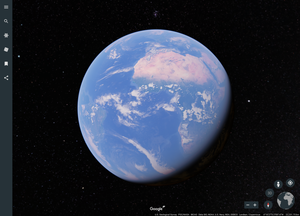
Google Earth has not received any major updates since 2013, but it is a software that uses amazing technology to make you feel like you are traveling around the world.
Free map software
- Web
A web app that displays aerial photographs from above, street views on the ground, and 3D polygon views of the Earth.On April 18, 2017, the desktop app was upgraded to a web app that can be used in the Chrome browser.
The images used in this software are taken from satellites. The aerial images are viewable anywhere in the world, not just Japan. In addition to aerial images, 3D views of urban areas and Street View views are also available. You
can bookmark places you want to see, or travel anywhere in the world with "I'm feeling lucky."Supported OS: Windows, Mac, Linux, iOS, AndroidProvided by: Google Inc.- PC software that allows you to view time-series topographical maps from the Meiji and Taisho eras to the present day
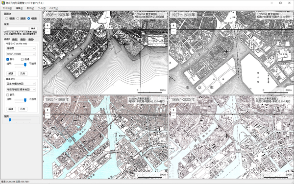
This is PC-only software for the "Konjaku Map on the Web," a web service that allows you to view chronological maps.
From the 2,325 included maps, you can view topographical maps from the Meiji and Taisho periods to the present day for areas such as the Tokyo metropolitan area, the Chukyo region, and the Keihanshin region.
You can use the two-screen or four-screen display to line up chronological maps and check the differences, or place markers so you can view checked locations at any time.
In addition to maps from "Konjaku Map on the Web," it also supports viewing multiple map services, including Geospatial Information Authority of Japan maps, aerial photographs, population maps, and railway lines.Supported OS: Windows 7/8/8.1/10Version: 3.0.2 (2015/12/07)Provided by: Kenji Tani* When using Windows 7, transparent images may not be displayed properly. - High-performance map management software using the Internet
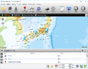
You can register points, lines, and polygons on a map and manage location information. It supports the Geospatial Information Authority of Japan (GSI) map service, OpenStreetMap, and Google Maps. If you have a GPS-equipped device (PC/tablet), you can also display your current location. It offers a wide range of functions, including full-text search of registered data, filtering of displayed data by registration date, calculation of distance and area of clicked locations, displaying maps using a cache when not connected to the internet, and sharing data with other PCs by saving data to the cloud.
Supported OS: Windows 7/8/8.1/10Version: 3.3.2 (2017/12/02)Provided by: YourSide Software Designer*Some functions, such as the ability to import photo location information (geotags) and collaborative editing via external database (MySQL) connection, require the purchase of a license. - Software that displays the location information of photos on a map
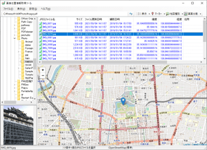
If a photo has GPS location information, this software displays a marker on the map to show its location.
It also supports displaying markers on multiple photos, and clicking on a marker will display the Exif information.
OpenStreetMap, Geospatial Information Authority of Japan Maps, and Google Maps can be used for map display.Supported OS: Windows 10/11Version: 2.4.1 (2024/05/11)Provided by: OsadaSoft*To use Google Maps, you will need to obtain a Google API key. To obtain a Google API key, you will need to enter your payment information.